> For the complete documentation index, see [llms.txt](https://docs.ineom-tsel.mit.id/llms.txt). Markdown versions of documentation pages are available by appending `.md` to page URLs; this page is available as [Markdown](https://docs.ineom-tsel.mit.id/etsa/recovery-map.md).

# Recovery Map

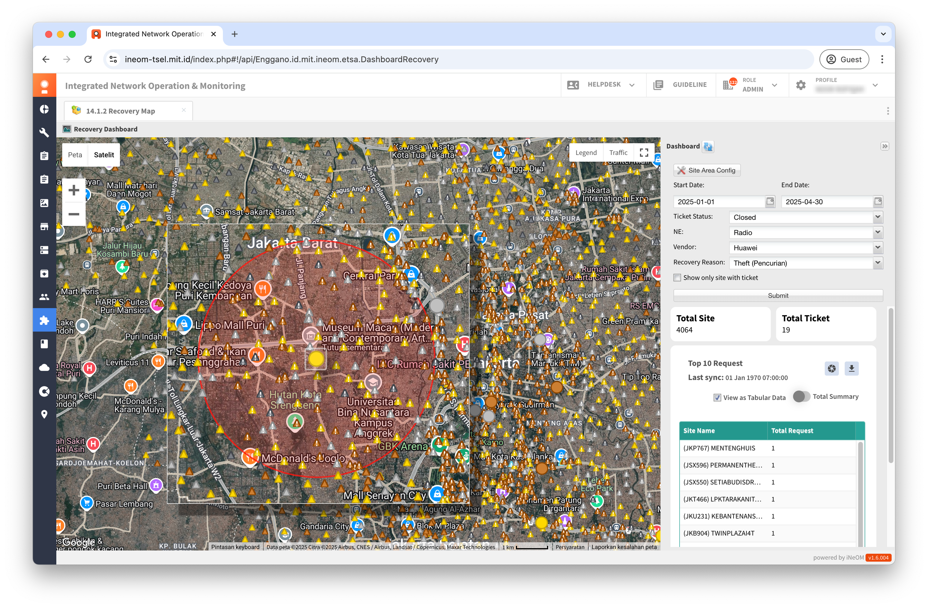
Proses menampilkan recovery map:

1. Klik menu 14.1.2 Recovery Map (eTSA Feature).
2. Klik tombol **`Site Area Config`**.
3. Pilih site area.
4. Klik tombol **`Submit`**.

<div><figure><img src="/files/XfIm8DhZtkc8IXGFhL4H" alt=""><figcaption></figcaption></figure> <figure><img src="/files/ZUZowHV3BYtMhfaC4rN2" alt=""><figcaption></figcaption></figure> <figure><img src="/files/21KE6APTZj8kcYOVYvz9" alt=""><figcaption></figcaption></figure></div>

5. Pilih start date-end date, ticket status, NE, Vendor, dan Recovery Reason.
6. Klik tombol **`Submit`**.

<div><figure><img src="/files/2WCOEfYlbKUrDNSIxA0f" alt=""><figcaption></figcaption></figure> <figure><img src="/files/ALimANQ9CM5iAuB9Pu7z" alt=""><figcaption></figcaption></figure></div>

Pada halaman Recovery Map terdapat beberapa fitur, antara lain:

* Melakukan capture chart

<figure><img src="/files/kqbgvaYrx0H4WclyV5Vz" alt=""><figcaption></figcaption></figure>

* Melakukan export data

<figure><img src="/files/suX5RO1WqNHqkgDDpMwt" alt=""><figcaption></figcaption></figure>

* Menampilkan hasil filter data, berupa total site dan total ticket yang dapat ditampilkan dalam bentuk diagram atau tabel.

<div><figure><img src="/files/y2kB0ZCMt7kpANa9sdrG" alt=""><figcaption></figcaption></figure> <figure><img src="/files/rxrScb1QG0s5xVuLmPpC" alt=""><figcaption></figcaption></figure></div>

* Menampilkan hasil filter data dalam tampilan peta atau satelit.

<div><figure><img src="/files/19zancFQlufm4nAfynho" alt=""><figcaption></figcaption></figure> <figure><img src="/files/HGoEHfXle0c1q6CsdjM7" alt=""><figcaption></figcaption></figure></div>

* Menampilkan site yang tidak ada tiket recovery map.

<figure><img src="/files/gJLrDt1qkdn4yZfix0Xk" alt=""><figcaption></figcaption></figure>

* Menampilkan radius 3 km dari site yang ditandai dengan lingkaran berwarna merah.

<figure><img src="/files/6cCdFVkglc8EX40jSzVR" alt=""><figcaption></figcaption></figure>

* Menampilkan deskripsi dari beberapa ikon pada peta/satelit.

<figure><img src="/files/dhjcPkrJHk1f4DALmqLa" alt=""><figcaption></figcaption></figure>

* Menampilkan kondisi lalu lintas secara real-time.

<figure><img src="/files/y79kHBaWMLJQWkDN2ODE" alt=""><figcaption></figcaption></figure>

* Menampilkan detail tiket.

<div><figure><img src="/files/WarkgivAoRYhNDeMHIbx" alt=""><figcaption></figcaption></figure> <figure><img src="/files/ULtCMO72k4qCcjoNXjfS" alt=""><figcaption></figcaption></figure> <figure><img src="/files/bOfAlhHnVWXqYIuleCls" alt=""><figcaption></figcaption></figure></div>